The Crossing Under the Town: A Walker's Hunt for Old Fordbridge
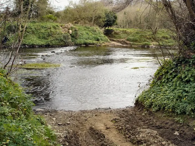
Photo: Kay Atherton, CC BY-SA 2.0, via Wikimedia Commons
Fordbridge is a town named after a verb. Not a saint, not a lord, not a battle: a crossing. Before there was a bridge, there was a ford, and before there was a town, there was a path down to the water. That is the story in the name, and it is still there if you know where to look. This is a short walk—about a mile and a half, an hour at a gentle pace—that follows the old crossing through the streets that grew around it. Wear boots. Look down.
Start at the market square
Begin under the clock, with your back to the high street. The obvious way to go is down Bridge Street, which is exactly what the name suggests: the road that led to the bridge. But the ford came first, and the bridge came later, and the old route probably ran a little to the north. Walk down Bridge Street anyway. Halfway along, on the left, there is a patch of worn setts beside the kerb. They are easy to miss. They are also a clue.
The setts are older than the pavement around them, and they sit on a line that runs towards the river. Nobody has proved that this was the approach to the ford, but it is the kind of detail that local historians argue about in the pub. The street itself was widened in the nineteenth century, and the kerb line has moved more than once. What survives is a fragment—a few feet of stone that may, or may not, have felt the hooves of cattle on their way to market.
Down Ford Lane
Turn left at the bottom of Bridge Street and follow Ford Lane. The name is not subtle, and it is not wrong. This was the lane that led to the ford, and later to the mill. On the right, a low wall has a faded painted sign for a builder who has long since retired. On the left, a drain cover carries the name of a foundry in a town thirty miles away. These are not grand monuments. They are the small, ordinary things that survive when a place changes.
Keep going until the lane bends. At the bend, look at the kerb on the outside of the curve. There is a line of darker stones, worn smooth in the middle. They could be nothing. They could be the edge of an old causeway. This is the mystery at the heart of the walk: we know there was a ford, but we do not know exactly what it looked like. Was it a wide, shallow gravel shelf? A paved crossing with a stone causeway? A series of stepping stones for people on foot, with a deeper channel for carts? The maps show the route, but they do not show the texture.
The old ford meadow
At the end of Ford Lane, the road opens out towards the river. This is Old Ford Meadow, a strip of grass and scrub that floods most winters. In summer it is a good place for a picnic. In November it is a good place to imagine. Stand with your back to the lane and look towards the water. The far bank rises slightly, and there is a line of trees that follows the old boundary. Somewhere between here and there, people crossed.
The first written mention of the ford is in a charter from the thirteenth century, though the crossing is almost certainly older. By the sixteenth century there was a bridge, and by the eighteenth the ford was being described as old. The people who used it were not tourists. They were drovers taking cattle to market, mill workers walking to the mill, children going to school, and anyone who did not fancy the long way round. A ford is a democratic piece of infrastructure. It does not care who you are, as long as you are prepared to get your feet wet.
Look down at the pavement
The walk back goes along the river path and up Mill Lane. This is where the clues get smaller. On the corner of Mill Lane and Water Street, there is an iron bollard with a rounded top. It is not old enough to be medieval, but it marks the edge of the old wharf. Further up, a brick wall has a stone plaque with a flood mark from 1947. The water came higher than the plaque, apparently, which is worth thinking about as you walk uphill.
Then there is the pavement itself. Outside the old school, there is a strip of cobbles set into the tarmac. They are worn, uneven, and slightly higher than the modern surface. They may have been part of the road to the ford. They may have been part of a later yard. This is the joy and the frustration of local history: you find a clue, and then you have to decide how much weight to put on it.
The mystery that remains
The ford has been written over, not erased. It is in the street names, in the flood marks, in the worn stones and the old maps. The tithe map of the 1840s marks a field as Ford Meadow. The Ordnance Survey of the 1880s shows Old Ford in italic letters beside the river. A postcard from the early 1900s shows a footbridge and a wide, shallow stretch of water that looks suspiciously like a ford. None of these things proves exactly where the crossing was. Together, they make a convincing case that it was here, or hereabouts.
If you want to dig deeper, the local studies room at Fordbridge Library holds the maps, photographs and deeds. The staff are patient, and the photocopier is reasonable. But you do not need to be an historian to enjoy the walk. You just need to look down, and to remember that the town was a crossing before it was a town. The name is a clue. The pavement is a clue. The rest is a good story.